Flood Watch through 6 pm Saturday for the entire Ozarks area

A Flood Watch remains in effect for the entire Ozarks region through 6 PM Saturday with additional widespread 2 to 4 inches of rainfall forecast.
• Round of heavy rainfall tonight and another round Sunday. The low-end risk for isolated strong to severe thunderstorms through Friday evening. Severe risk is diminished for Sunday due to lack of instability.
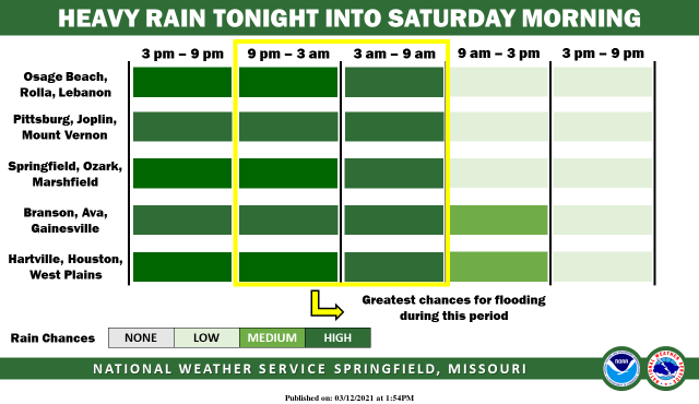
Additional amounts 2 to 4 inches, with localized higher amounts possible through Sunday. The heaviest round of showers and storms looks to occur tonight across southern Missouri, mainly along and south of I-44. Recent rainfall over the last 48 hours has resulted in increased soil saturation. Additionally, a lack of ground vegetation in early Spring will result in more runoff.
Related Content

Morgan County Man Charged
1 day ago

Former Scout Volunteer sentenced to Prison
2 days ago

Commemorative Bricks Increase in Price
2 days ago